 www.geodatenkatalog.de (S2L)
Keyword
Western Baltic Sea
11 record(s)
Provided by
Type of resources
Available actions
Topics
Keywords
Contact for the resource
Update frequencies
Service types
-
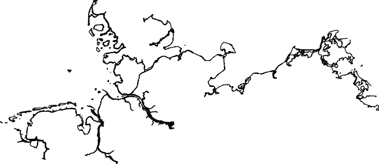
It is about an automated derived coastline of the North Sea and Baltic Sea from different scale ranges of the Electronic Navigational Chart (ENC) corresponding to the relative coverage area – see nautical product catalogue. The ENCs are produced in accordance with the valid international standard S-57. It consists of generalised lines in the different ENC scale ranges Approach, Harbour and Berthing. None of these scale ranges provides a continuous coastline. The derived coastline consists of natural and man-made (e. g. piers) elements. As an alternative, there is a further coastline available. Information on this high-precision coastline is available via customer@bsh.de.
-
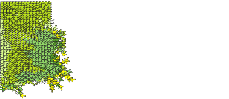
Hourly tidal currents (related to high water Helgoland) of the German coastal waters and neighbouring regions (inner German Bight and Western Baltic) in a horizontal resolution of 900 meters. The information is based on a tidal current simulation using the BSH circulation model BSHcmod.
-
Hourly tidal currents (related to high water Helgoland) of the German coastal waters and neighbouring regions (inner German Bight and Western Baltic) in a horizontal resolution of 900 meters. The information is based on a tidal current simulation using the BSH circulation model BSHcmod.
-
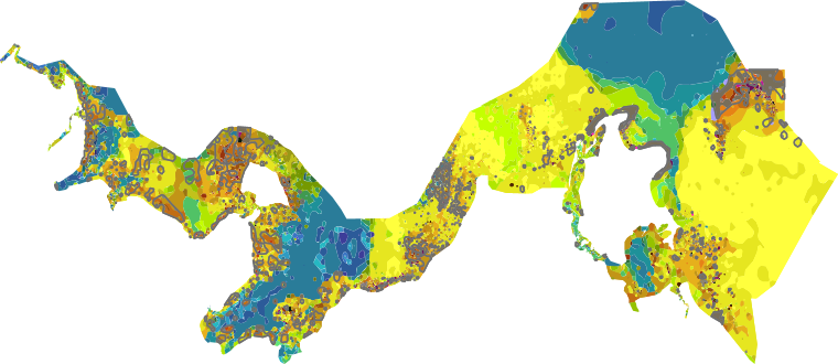
Data on the distribution of seabed sediments in the Baltic Sea of various classifications in a scale of 1:100.000. For more information, please visit: https://gdi.bsh.de/en/data/Seabed-Sediments-on-a-scale-of-1-100-000-in-German-Baltic-Sea_Information_Meeresbodensedimente_im_Massstab_1_zu_100000_in_der_deutschen_Ostsee_DE.pdf
-
Data on seabed structure in the North Sea and Baltic Sea. For more information, please visit: https://gdi.bsh.de/en/data/Seabed-Sediments-on-a-scale-of-1-10-000-in-German-sea-area_Information_Meeresbodensedimente_im_Massstab_1_zu_10000_im_deutschen_Seegebiet_DE.pdf
-
Data on seabed structure in the North Sea and Baltic Sea. For more information, please visit: https://gdi.bsh.de/en/data/Seabed-Sediments-on-a-scale-of-1-10-000-in-German-sea-area_Information_Meeresbodensedimente_im_Massstab_1_zu_10000_im_deutschen_Seegebiet_DE.pdf
-
Data on seabed structure in the North Sea and Baltic Sea. For more information, please visit: https://gdi.bsh.de/en/data/Seabed-Sediments-on-a-scale-of-1-10-000-in-German-sea-area_Information_Meeresbodensedimente_im_Massstab_1_zu_10000_im_deutschen_Seegebiet_DE.pdf